
NOAA says El Niño has a greater than 90% chance of becoming very strong this winter, while long-range forecasts differ on exactly what that will mean for Illinois
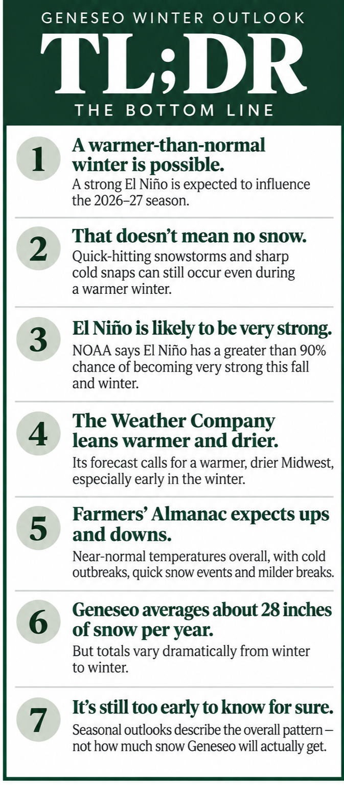
It is still too early to know how many inches of snow Geneseo will see this winter or when the season's biggest storm might arrive, but several long-range winter outlooks are now available — and they share one important feature.
El Niño is expected to have a major influence on the winter of 2026–27.
The National Oceanic and Atmospheric Administration, The Weather Company and the Farmers’ Almanac have all released information about the coming winter. Their forecasts don't agree on every detail for the Midwest, but the developing El Niño provides a common thread.
For western Illinois, the current outlooks generally leave room for snow and sharp cold spells while suggesting that persistent cold and snow throughout the entire winter may be less likely.
NOAA: El Niño could reach historic strength
The most significant development comes from NOAA's Climate Prediction Center.
In its Sept. 10 update, NOAA reported that El Niño is strengthening and has a greater than 90% chance of becoming a very strong event during fall and winter 2026–27.
NOAA goes even further. The agency currently estimates a 75% chance that El Niño reaches a level during October through December that would exceed the strength of previous events in records dating to 1950, based on the Relative Oceanic Niño Index used by the Climate Prediction Center.
That doesn't mean a record-breaking winter is coming to Illinois.
El Niño describes a large-scale warming of waters in the tropical Pacific Ocean. That warming can alter atmospheric circulation and shift weather patterns thousands of miles away.
Historically, strong El Niño winters tend to favor a more active southern storm track while portions of the northern United States experience relatively warmer and drier conditions.
NOAA stresses that those historical tendencies are probabilities, not guarantees. Even an unusually strong El Niño does not determine the weather in a particular community or prevent periods of snow and severe cold.
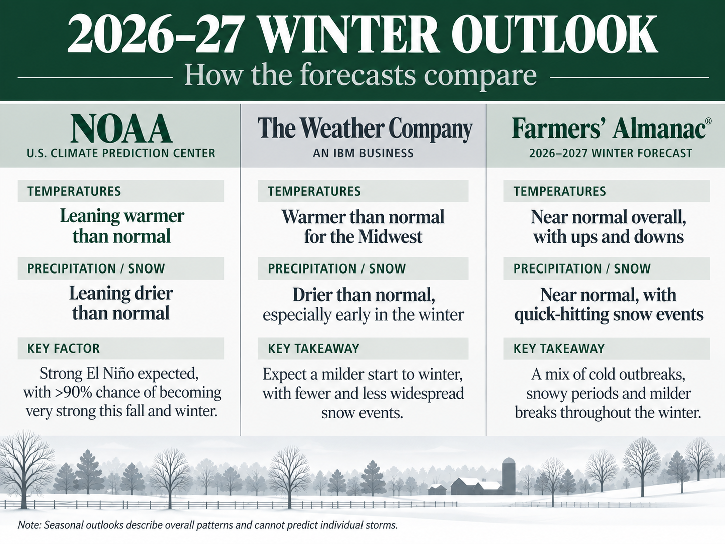
NOAA's seasonal outlook leans warmer
NOAA's Climate Prediction Center is already publishing its long-range outlooks extending through the winter months.
Unlike a conventional weather forecast, NOAA's seasonal products don't attempt to predict the temperature or snowfall on a particular day months in advance. Instead, they estimate whether temperatures and precipitation over a three-month period are more likely to finish above, below or near their historical averages.
The agency says El Niño is playing an important role in those long-range forecasts. Its August seasonal discussion already favored above-normal temperatures across the Great Lakes during the fall and noted a tilt toward below-normal precipitation there. NOAA's outlooks now extend through December-January-February and beyond.
That distinction is important: NOAA is not predicting that Geneseo will have a snowless or warm winter. Seasonal averages can conceal considerable variation, including individual snowstorms and short periods of bitter cold.
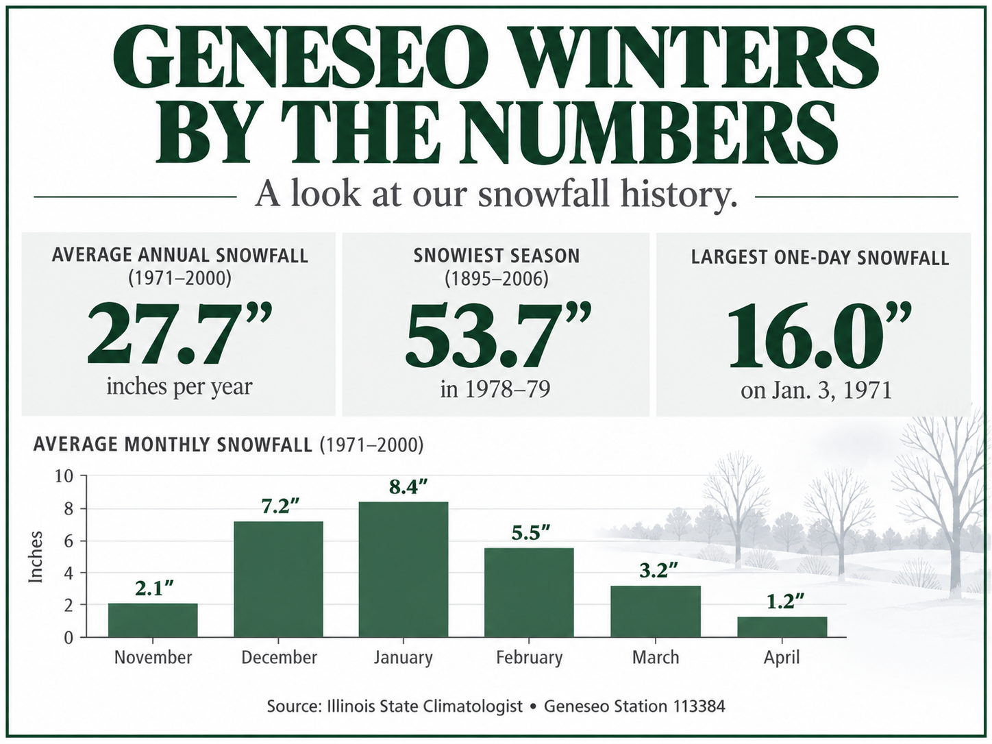
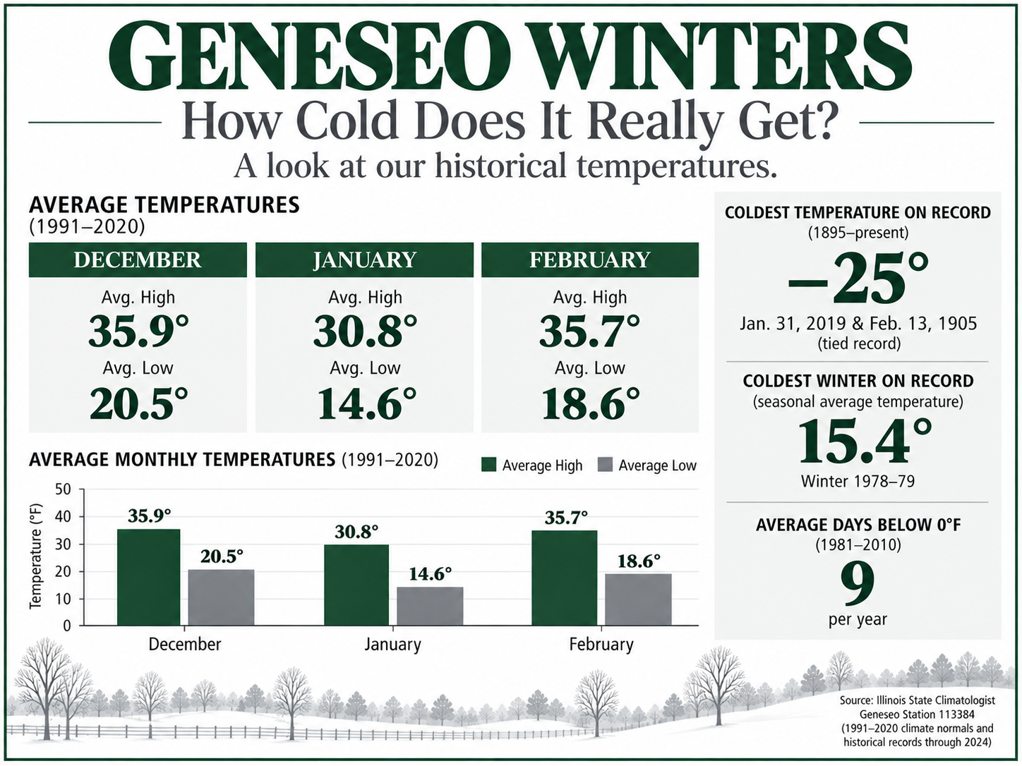
The Weather Channel expects a warmer, drier Midwest
The Weather Channel's winter forecast, released Sept. 11, is more specific about how it expects the developing El Niño to affect the Midwest.
Its December-through-February outlook calls for a warmer and drier winter from the Midwest into portions of the northern Rockies and Pacific Northwest.
December stands out.
The Weather Channel expects an unusually warm beginning to winter in the Midwest and Great Lakes, with some of the largest departures from average temperatures occurring in this part of the country.
Above-average temperatures are expected to continue across much of the northern half of the country in January.
By February, the forecast allows colder air to become more established across northern portions of the country. Even then, however, the Midwest and Great Lakes are expected to trend warmer than average.
The reason again comes back largely to El Niño.
A strong El Niño typically strengthens the southern branch of the jet stream, increasing storm activity across the southern United States while leaving portions of the northern United States relatively warmer and drier.
That could limit overall snowfall opportunities in the Midwest, but it certainly doesn't eliminate them.
Farmers’ Almanac sees more ups and downs
The Farmers’ Almanac paints a somewhat different picture for Illinois.
Its 2026–27 forecast places Illinois in its Great Lakes and Midwest region and predicts temperatures averaging near normal overall, rather than the warmer winter forecast by The Weather Channel.
But “near normal” doesn't mean consistently moderate.
The Almanac expects fast-moving clipper systems, sudden cold snaps, snow squalls, blustery winds and brief periods of bitter cold. Those conditions are expected to be interrupted frequently by milder weather.
For places such as Chicago and Indianapolis, the publication specifically anticipates quick-moving systems capable of producing brief accumulating snow rather than prolonged snowstorms.
Geneseo isn't in one of the primary Great Lakes lake-effect snowbelts, so that portion of the Almanac's forecast is less applicable locally.
The Almanac also anticipates frequent cycles of thawing and freezing across the central United States, potentially producing rapidly changing road and field conditions.
The forecasts aren't as contradictory as they first appear
A warmer-than-average winter does not mean there won't be cold weather, and a drier-than-average winter does not mean there won't be significant snowstorms.
That's one reason long-range winter predictions can sound contradictory.
The Weather Channel sees the entire winter averaging warmer and drier across the Midwest.
The Farmers’ Almanac sees temperatures closer to normal overall, with pronounced swings between cold and mild periods.
NOAA provides probabilities rather than a specific narrative for Geneseo, while emphasizing that an exceptionally strong El Niño could increase the likelihood of weather patterns historically associated with the phenomenon.
All three leave plenty of opportunity for individual winter storms.
A week of bitter cold can occur during an otherwise warmer-than-average winter. Likewise, one major snowstorm can produce a substantial portion of a community's seasonal snowfall even during a relatively dry winter.
Why NOAA's forecast is different from the Almanac
There is also an important difference in how these forecasts are produced.
NOAA's Climate Prediction Center uses observations of the atmosphere and oceans, multiple climate models, historical patterns and large-scale climate signals such as El Niño to develop probabilistic seasonal outlooks.
The Farmers’ Almanac uses a proprietary forecasting method that it says incorporates natural cycles, solar activity, lunar influences and historical weather patterns. The publication says those calculations are now supplemented by modern meteorological information, satellite observations, computer modeling and analysis of large-scale atmospheric and ocean patterns. Its complete formula is not publicly disclosed.
The Weather Channel relies on modern meteorological models, climate patterns and professional meteorological analysis for its seasonal outlook.
For that reason, the three products shouldn't necessarily be treated as three equivalent scientific forecasts. NOAA's outlook provides the federal government's official climate forecast, while the Farmers’ Almanac offers its own proprietary long-range prediction.
What does all of this mean for Geneseo?
For now, perhaps the most useful conclusion is that there isn't strong evidence pointing toward an exceptionally snowy or relentlessly cold winter in western Illinois.
The Weather Channel leans warmer and drier for the Midwest. The Farmers’ Almanac expects something closer to normal temperatures but with quick snow events, cold outbreaks and frequent warmer breaks.
Meanwhile, NOAA has identified the much larger weather story that could influence both: an El Niño that is already strengthening and has a greater than 90% chance of becoming very strong this fall and winter.
Exactly how that translates to Geneseo won't become clear until much closer to individual weather events.
Seasonal forecasting can provide clues about the background pattern months in advance. It cannot tell residents whether there will be six inches of snow on a Tuesday in January.
So far, though, the signals point more toward a changeable winter — potentially warmer and somewhat drier overall, but still capable of delivering quick snowstorms and sharp blasts of Midwestern cold.
Sources
NOAA Climate Prediction Center seasonal outlooks
The Weather Company 2026–27 winter outlook
Farmers’ Almanac 2026–27 winter forecast